Showing posts with label Jöklar. Show all posts

Wednesday, May 15, 2013

Veggspjald á Final Ice2sea Open Forum

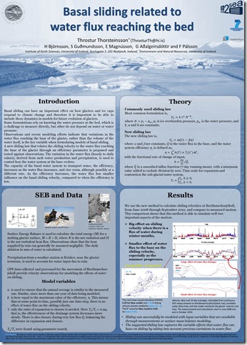
Háskóli Íslands tók þátt í stóru verkefni á vegum EU sem kallast Ice2sea. Meðal niðurstaðna í verkefninu er betra mat á mögulegri hækkun sjávar (95% líkur að verði innan við 1 m til ársins 2100). Framlag jöklahóps HÍ varðaði botnskrið jökla, eins og skoða má á veggspjaldinu hér að neðan.

Thorsteinsson_SEBSliding

Í mjög stuttu máli þróuðum við aðferð þar sem breytileiki í vatnsmagni sem nær til botns ákvarðar getu þess vatnskerfis sem er á botni til að flytja vatnið. Þannig valda snöggar breytingar í vatnsmagni hlutfallslega miklu botnskriði í samanburði við samskonar breytingar í vatnsmagni sem verða á reglubundinn hátt, til dæmis dægursveifla á sumrin.

ice2sea_logo

Tuesday, July 24, 2012

Allur Grænlandsjökull að bráðna um miðjan júlí

Ný gögn, sem flétta saman athuganir frá 3 gervitunglum, sýna að nánast allt yfirborð Grænlandsjökuls var að bráðna þann 12. júlí síðastliðinn. Það er enn ekki ljóst hvort megnið af vatninu mun frjósa aftur, eða hvort þetta muni valda töluverðri aukningu í heildarbráðnun jökulsins þetta afkomuárið.

Myndirnar hér að neðan sýna hvar bráðnun átti sér stað á yfirborði Grænlandsjökuls þann 8. og 12. júli, 2012. Myndin frá 8. júlí er svipuð því sem við þekkjum síðastliðin ár, um það bil helmingur yfirborðsins að bráðna. En þann 12. júí er eitthvað allt annað uppi á teningnum !

En, eins og minnst var hér að ofan, þá gæti þetta verið stuttur og einangraður atburður með lítil áhrif – nema auðvitað fyrir ískjarna framtíðar, en svona lagað virðist gerast á um 150 ára fresti, síðast 1889 -  …

Credit: Nicolo E. DiGirolamo, SSAI/NASA GSFC, and Jesse Allen, NASA Earth Observatory

Thursday, April 5, 2012

Enginn ís á Öskjuvatni

Enginn ís er á Öskjuvatni þessa dagana. Þetta sést greinilega á gervitunglamynd frá NASA frá 2. apríl 2012.

20120402_modis_1340_crop

Öskjuvatn er dökki bletturinn fyrir miðju landi, aðeins til austurs.

Ekki eru margar skýringar til á þessu,ólíklegt virðist að veður spili þarna mikið hlutverk, önnur vötn ísi lögð á svipuðum slóðum. Þá stendur aukin jarðhitavirkni eftir sem líklegasta skýringin. Vatnið er djúpt, 220 m djúpt, þannig að aukning í jarðhita tekur tíma til að koma í ljós.

Monday, April 2, 2012

Neikvæð heilsuáhrif grófs svifryks

Enn bætast við rannsóknir sem sýna neikvæð áhrif svifryks.

Í þetta skiptið er nýleg rannsókn í Stokkhólmi, Svíþjóð, sem sýnir að gróft svifryk (milli PM10 og PM2.5) eykur dánartíðni (e. mortality) um 1.68% fyrir hækkun um 10 micro-g/m3.

Uppspretta þessa grófa svifryks í Stokkhólmi er helst uppspænt malbik, en einnig geta slit á dekkjum,bremsum og slíku, auk sandstorma verið uppsprettur.

Greinin:
Kadri Meister, Christer Johansson, and Bertil Forsberg. Estimated Short-Term Effects of Coarse Particles on Daily Mortality in Stockholm, Sweden. Environmental Health Perspectives, 120(3); March 2012.
Umfjöllun á mbl.is:
http://mbl.is/frettir/taekni/2012/04/02/nagladekk_ogna_heilsunni/

Friday, March 9, 2012

Ný grein um ösku og heilsu

Ný grein í BMJ open um fyrstu niðurstöður rannsókna á heilsufari íbúa í nágrenni Eyjafjallajökuls eftir gosið 2010.

Í stuttu máli virðist askan ekki hafa haft verulega alvarleg áhrif, engin bráðatilfelli, fyrir utan ertingu í öndunarfærum og að þeir sem höfðu astma fundu fyrir meiri áhrifum.

Tilvitnun:

Hanne Krage Carlsen, Thorarinn Gislason, Bryndis Benediktsdottir, Thorir Bjorn Kolbeinsson, Arna Hauksdottir, Throstur Thorsteinsson, Haraldur Briem. 2012.
A survey of early health effects of the Eyjafjallajökull 2010 eruption in Iceland: a population-based study.
BMJ Open 2012;2:e000343. doi:10.1136/bmjopen-2011-000343 (Paper on BMJ Open web site)

Tuesday, January 10, 2012

Greenland getting darker

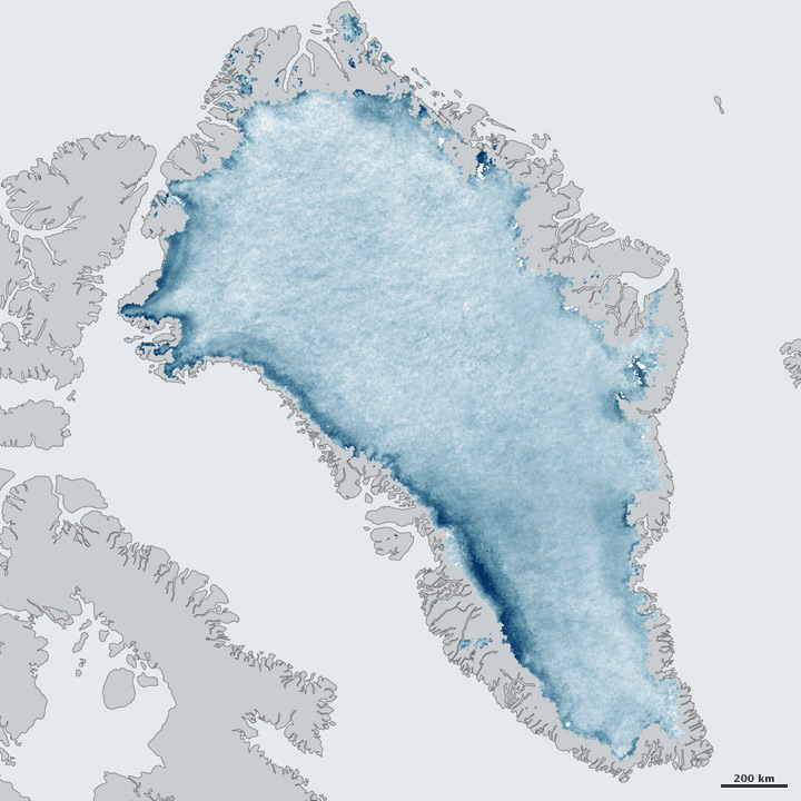
Melt ponds, dust and changes in size and shape of the snow crystals (near center) are making the Greenland ice sheet darker. That leads to more energy being absorbed – more melting …

NASA has a great map showing this – comparing reflectiveness in June – August 2011 to average for same period in 2000 – 2006.

Greenland’s Ice Is Growing DarkerColor bar for Greenland’s Ice Is Growing Darker

Source http://earthobservatory.nasa.gov/IOTD/view.php?id=76916&src=eorss-iotd

Wednesday, November 23, 2011

Ísfingur teygja sig niður

Magnað myndband sem sýnir hvernig salt sem hafísinn losar sig við sekkur og myndar ísfingur sem ná niður á botn.
Enn ein snilldarmyndatakan frá BBC.

Deathly ice finger caught on film: A bizarre underwater "icicle of death" is captured on camera for the first time by BBC filmmakers.

Tuesday, August 16, 2011

Plöntusvif í Barents hafi

N_NorwayFinland_SeaArctic
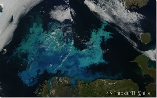
Gervitunglamynd (NASA MODIS) teking þann 16. ágúst, 2011, yfir Barents hafinu (sjá kort hér að neðan).
(Mynd NASA/Rapidfire)
Plöntusvif, eða nánar blaðgrænan (e. chlorophyll) litar hafið skemmtilega á þessari mynd – sjá nánar hér að neðan (á ensku).
BarentsSea_googleMap
Smellið á myndir til að fá stærri útgáfu (Kort frá Google maps)
Um plöntusvif og blaðgrænu
At the base of the ocean food web are single-celled algae and other plant-like organisms known as phytoplankton. Like plants on land, phytoplankton use chlorophyll and other light-harvesting pigments to carry out photosynthesis, absorbing atmospheric carbon dioxide to produce sugars for fuel. Chlorophyll in the water changes the way it reflects and absorbs sunlight, allowing scientists to map the amount and location of phytoplankton. In many coastal areas, the rising slope of the sea floor pushes cold water from the lowest layers of the ocean to the surface. The rising, or upwelling water carries iron and other nutrients from the ocean floor.
(Adapted from
http://earthobservatory.nasa.gov/GlobalMaps/view.php?d1=MY1DMM_CHLORA)


ThTh_symbol Þröstur Þorsteinsson.

Sunday, August 14, 2011

Sand- og ösku stormur á Suðurlandi

Á Raufarfelli náði styrkur svifryks (PM10) 590 micro-g/m3 rétt fyrir klukkan 16:00 í dag, 14. ágúst 2011.
Sterk norðanátt blæs sandi af Landeyjasandi yfir Vestmannaeyjar og væntanlega ösku af svæðinu nærri Mýrdalsjökli.
Í Stórhöfða, Vestmannaeyjum, var vindurinn úr norðri, 21 m/s kl. 16:00. Milli 12 og 13 í dag var vindurinn 15 til 18 m/s úr NNA.
20110814_modis_A2011226_1235
Gervitunglamynd tekin kl. 12:35 af Terra tungli NASA (mynd NASA/Rapidfire og VÍ).
ThTh  Þröstur Þorsteinsson.
Umhverfis- og auðlindafræði & Jarðvísindastofnun Háskólans, Háskóli Íslands, Sturlugata 7, 101 Reykjavík.

Saturday, August 13, 2011

Öskustormur af yfirborði Vatnajökuls

kort af Vatnajökli - lmi.is
Grímsvötn, staðsett þar sem “T” í Vatnajökull er á kortinu (frá LMI.is).
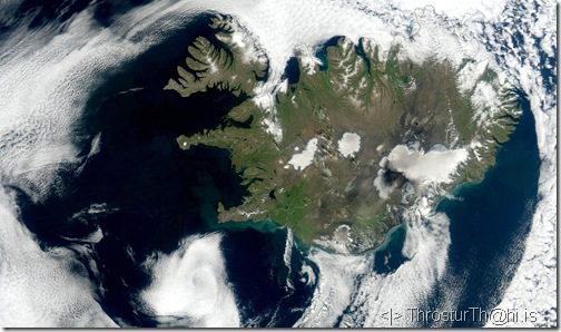
Síðastliðinn sunnudag, þann 7. ágúst, 2011, um klukkan 14:05 var greinilegur öskustormur frá Grímsvatna-svæðinu á Vatnajökli.
20110807_modis_A2011219_1405
Þessi mynd frá 14:05 (að ofan), og frá 14:20 (mynd að neðan), sýna þetta nokkuð vel (myndir frá NASA/Rapidfire og VÍ).
20110807_modis_P2011219_1420
Takið líka eftir flotta lægðasnúðnum rétt fyrir utan Reykjanesið.
Á BTD mynd sést þetta einnig mjög vel (vann með Hróbjarti Þorsteinssyni (VÍ) að BTD; hann benti mér einnig á þennan atburð).
20110807_modis_btd_A2011219_1405
Samsé, nokkuð óvanalegur atburður, öskufok af yfirborði jökuls.

Wednesday, March 9, 2011

Some Antarctic ice is forming from bottom

From http://www.eurekalert.org/pub_releases/2011-03/leo-sai030111.php


Caption: Radar image shows the Gamburtsev Mountains (bottom) overlain by the ice sheet, which has been deformed by a bulge of refrozen ice (center).
Credit: Courtesy Bell et al., 2011

Thursday, December 16, 2010

Kuldinn í BNA og Evrópu / The cold spell in USA and Europe

(Íslenska neðan við myndina)

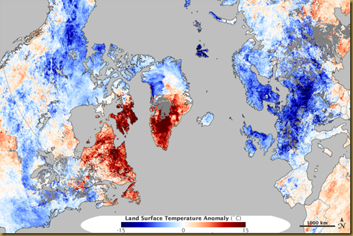
The Atlantic Oscillation (AO) has caused cold temperature throughout most of Europe and USA. However, parts of Greenland for instance, have been unseasonably warm.

The image below shows the temperature anomaly for 3 – 10 Desember 2010, as compared to the average for the same dates in 2002 – 2009.

LSTempAnom_3_10des2010_copm2002_2009 
NASA Earth Observatory image created by Jesse Allen, using data provided courtesy of the NASA/GSFC Distributed Active Archive Center. Caption by Holli Riebeek.

Svokölluð AO sveifla, sem ræðast af þrýstingsmun milli háþrýstisvæði nær miðbaug og lágrþrýstisvæða yfir heimskautinu, er nú í þeim fasa (kallaður neikvæður, lítill þrýstimunur) að kalt er víða í Evrópu og BNA, en hlýtt t.d. á Grænlandi.

Myndin hér að ofan sýnir hitafrávik fyrir dagana 3 – 10. desember, 2010, í samanburði við meðaltal sömu daga árin 2002 – 2009.

Thursday, December 2, 2010

Lítið orðið eftir af nýjum fiskveiðisvæðum / World running out of new places to fish: study

Frétt um það hvernig tekist hefur að viðhalda miklum fiskveiðum með því að stækka veiðisvæði, þannig að nú er nánast ekkert nýtt veiðisvæði eftir, fyrir utan svæði sem lítið gefa af sér.


The world's fishing industry is fast running out of new ocean fishing grounds to exploit as it depletes existing areas through unsustainable harvesting practices, according to a study published Thursday.

World running out of new places to fish: study: VANCOUVER (Reuters)
Report published in the online journal PLoS ONE. (here)


From the news summary:

  • Expansion into unexploited fishing grounds allowed global catches to increase for decades, and disguised the fact that older areas were being depleted ...
  • ... most fishing is done by large companies ... companies can ignore the decline of older stocks by simply moving to new areas.
  • ... left only unproductive fishing areas on the high seas and the ice-covered waters of the Arctic and Antarctic for boats to move into.

Wednesday, September 8, 2010

Ráðleggingar vegna svifryksmengunar

Viðbrögð vegna svifryksmengunar (PM10) fara eftir styrk svifryks í andrúmslofti.

Hér að neðan er tengill á einskonar töflu, sem kort eða mynd, sem sýnir almenna flokkun á loftgæðum vegna styrks svifryksmengunar og helstu ráðleggingar fyrir hvern flokk.

Kortið má nálgast hér, bæði sem mynd (smámynd hér að neðan) og kort sem hægt er að "ferðast um".

Almennt er óþarfi að vera sérlega duglegur að vera úti ef magn svifryks í lofti fer yfir um 150 micro-g/m3. Ekki myndi ég láta barnið mitt sofa úti þegar styrkurinn fer yfir þessi mörk. Hinsvegar er ekki hættulegt að fara styttri ferðir, sér í lagi ef notaðar eru grímur þegar styrkurinn er sem mestur, nokkuð hundruð micro-g/m3.

Wednesday, August 25, 2010

France drains lake under glacier / Til stendur að dæla vatni undan jökli í Frakklandi

"French engineers are set to drain a lake that has formed under a glacier on Mont Blanc, and which threatens to flood a valley below."

The lake, which is said to contain 65,000 cubic metres (2.3m cubic ft) of water, was discovered last month during routine checks.
The engineers plan to dig a hole into the ice and pump the water away.
Vatni sem safnast hefur undir jökli á Mont Blanc verður dælt upp úr því ef áætlanir ganga eftir.
Map of France showing location of Mont Blanc
Image from the BBC web site (see link above).

Wednesday, August 18, 2010

Hitafrávik í júlí 2010 / Temperature anomaly in July 2010

temperature_gis_201007
temp_gis_201007_palette
Þessi mynd, frá NASA Earth Observatory, sýnir hitafrávik í júlí 2010 miðað við sama mánuð árin 1951 til 1980.
Hnattrænt var hitinn um 0.55°C hærri og jafnaði nánast hitametið, með árunum 1998 og 2005.

ENGLISH:

This image, from NASA Earth Observatory, shows the temperature anomaly for July 2010, compared to the average for the same month in 1951 to 1980. 

Globally the temperature was about 0.55°C higher than the mean, and practically as high as the highest years on record,1998 and 2005. 

Wednesday, July 21, 2010

China oil spill after pipe blast 'worse than thought' / Olíuslys í Kína

Fréttin / BBC news:
BBC News - China oil spill after pipe blast 'worse than thought'

Myndir / pictures:

Einnig var í fréttum að Kína hefur tekið fram úr BNA sem sú þjóð sem notar mesta orku í heiminum.
Also in the news that China has surpassed USA as the nation who uses the most energy.
Sjá / see http://www.bbc.co.uk/news/world-asia-pacific-10703518

Tuesday, July 20, 2010

Rannsókn á áhrifum gosösku á hafið / Volcanic ash team back at sea to gather more data

Alþjóðleg rannsókn á áhrifum gosöskunnar á lífríkið í hafinu er hafin.
Þessi frétt hér að neðan kemur frá BBC, Mbl.is var síðan með smá frétt, væntanlega unna úr þessari. Þekki ekki og virðist ekki koma fram í fréttinni hvort Íslendingar með í þessari rannsókn, mögulega, eða með aðra sjálfir ?

A team of scientists has returned to the North Atlantic to get more data on how the Icelandic volcanic eruption has affected the region's marine biology.


By Mark Kinver, Science and environment reporter, BBC News

They are assessing whether iron within the vast volcanic ash cloud entered the ocean, causing an extended bloom of tiny organisms known as phytoplankton.

The team, in the middle of a five-week cruise, have recorded "enhanced levels" of iron in samples they have collected.

The latest project follows an earlier cruise, carried out in the spring.

The international team of researchers are hoping to measure if trace elements from the ash have had an impact on the region's phytoplankton blooms.
"A hundred million cubic metres of ash was produced by the volcano - that must have gone somewhere and a large part has fallen into the ocean - so that is a significant iron source," said lead scientist Eric Achterberg, from the UK's National Oceanography Centre.
Professor Achterberg explained that the team had limited time to analyse data collected on their first cruise before they headed out to sea again.
"The guys only had six or seven weeks to pack and remobilise for the next cruise," he told BBC News.
However, he added that they did manage to glean some initial information: "For example, when they were right underneath the volcanic ash cloud in Iceland, they found that the iron levels were very high.
"But we have not got a really large-scale picture yet - there is so much data."
The area of the North Atlantic in which the researchers are collecting samples normally has very low inputs of iron and other nutrients from the atmosphere.
It was therefore assumed that phytoplankton were growing in a sub-optimum manner.
"The original objective for this cruise was to go out... and look at the conditions in the ocean after the massive spring bloom," explained Professor Achterberg.
"The hypothesis was that the system would have run out of iron by this point."
However, he added that the eruption in March could potentially change this.
"What we are doing is taking samples from the ocean, the atmosphere, and we are looking at biological growth in the ocean.
"We are seeing some enhanced levels (of dissolved iron) below the "mixed layers" of 20-40 metres deep.
"It may be a result of the volcanic ash, but we really need to have a better look at this on a wider scale."
'Unique opportunity'
If the ash from the eruption added a significant amount of iron to the ocean, the team hope to collect data to confirm that it did trigger extended phytoplankton blooms.
"It is something that we are hoping to see," said Professor Achterberg.
"This would also mean that the phytoplankton would take up more atmospheric CO2 than what it usually does in a normal year."
The expedition - aboard the RRS Discovery, a Natural Environment Research Council (Nerc) vessel - is part of a climate change project that is looking at the efficiency of phytoplankton to absorb atmospheric CO2 and sequester it in the deep ocean.
He went on to say that the cruise, which was originally planned five years ago, provided a "totally unique opportunity".
"Never, at this scale, have people been able to do this.
"Firstly, we do not get that many volcanic eruptions on this scale, and secondly, it is only recently that we have been able to take the iron sampling and carry out analysis in the manner that we can do now.
"It has luckily come together in a very nice manner."
Professor Achterberg said that the team hoped to make the results available "within months" of returning from the current cruise, which is scheduled to end in mid-August.